
Shared points of interest: Maps helping to coordinate digital health
By: Mark Herringer, Maguette Ndong, & Maeghan Orton
Maps are an important visualization tool. They translate information from values and text fields into something we can grasp more quickly. Throughout the global health sector, maps are being used to bring transparency to data sets in new ways—and to help foster coordination in delivering effective health programs.
Mapping health facilities
How many health facilities are there in a region? How far apart are they? When are they open? What services do they provide? Understanding the health capacity of a region is a vital asset for day to day operational work and in times of emergencies. Health facility registries are the building blocks of well-functioning health information systems supporting maternity care and health capacity planning, epidemic preparedness, immunization programs and disaster response.
However, maintaining registries of health facilities can be costly and difficult to coordinate. Different organizations and individuals will use lists that are not interoperable, and often times private sector and public sector health facilities are not mapped side by side. Siloed, duplicative, and often incomplete lists make it difficult to get a clear picture of the health capacity of an area. Without this clear picture, planning and response is made more difficult.
The Global Healthsites Mapping Project uses OpenStreetMap as the data store to achieve this interoperability.
By using OpenStreetmap as the data store multiple unstructured databases can be integrated, enhancing the reliability of the data through user validation, and encouraging collaboration between stakeholders. Citizens, academic institutions, businesses and organisations can help to establish this baseline health facility list and support the Ministry of Health in maintaining their facility registry.

With a range of partners, Healthsites leans on the methods and infrastructure of OpenStreetMap to establish a baseline of health facility data that can be maintained. With this improved data, stakeholders have rapid access to a shared, baseline view of health facilities and their services. In addition to OpenStreetMap, the data is made available through shape file downloads and an open API.
Mapping the sector
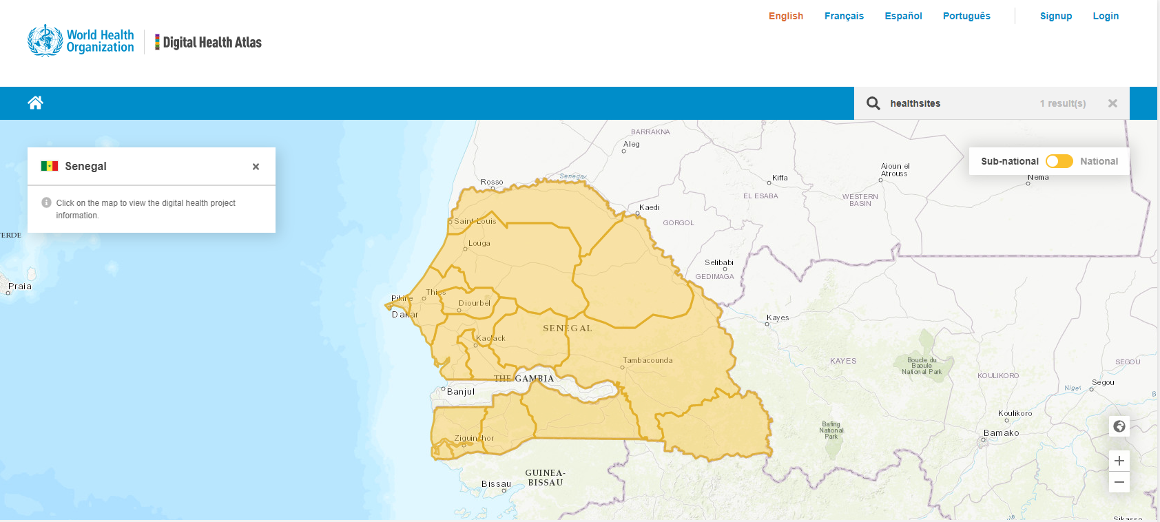
The Digital Health Atlas (DHA) is using maps to promote better coordination in the digital health sector more broadly. This open-source web platform is designed by the World Health Organization to help governments, technologists, implementers and donors quickly grasp ongoing digital health work across the globe. Currently, the DHA contains active projects from over 90 countries, making it the most comprehensive single registry of digital health projects.
By cataloging projects geographically, the DHA allow implementers to understand the other software platforms present in a specific country or region of a country, and to easily connect with implementation leads. The DHA enables direct contact with Project Leads through the DHA site, creating space for users to access the information needed to improve the planning, coordination and use of digital health information systems for health.
Deployments of tools like Healthsites.io are tracked in the DHA, enabling the global community of practice to take this information into consideration when designing their digital health deployments. From the DHA, a user can easily find the tool’s codebase, project design, and understand how it integrates with health information system components like the national Master Facility List (MFL). The Healthsites team is using the DHA to identify potential countries that could benefit from a healthsites.io deployment, as well as share the success of ongoing deployments.
Globally, digital health leads can register their work within the WHO’s DHA, establishing a way for ministries of health, investors and digital health implementers to understand the work being done. There are further opportunities to ensure work is in the right health facilities by leveraging the Healthsites information.
We are entering a new era in digital health, where data that was often captured in reports and spreadsheets becomes more usable and shareable within the Healthsites and DHA map-based platforms. When stakeholders have easier access to data, they are better equipped to take action in an efficient and effective way.
Learn more about Healthsites.
Get in touch to find out more or share data to OpenStreetMap.
Twitter: @sharehealthdata

Learn more about the Digital Health Atlas.
Website: https://www.digitalhealthatlas.org/